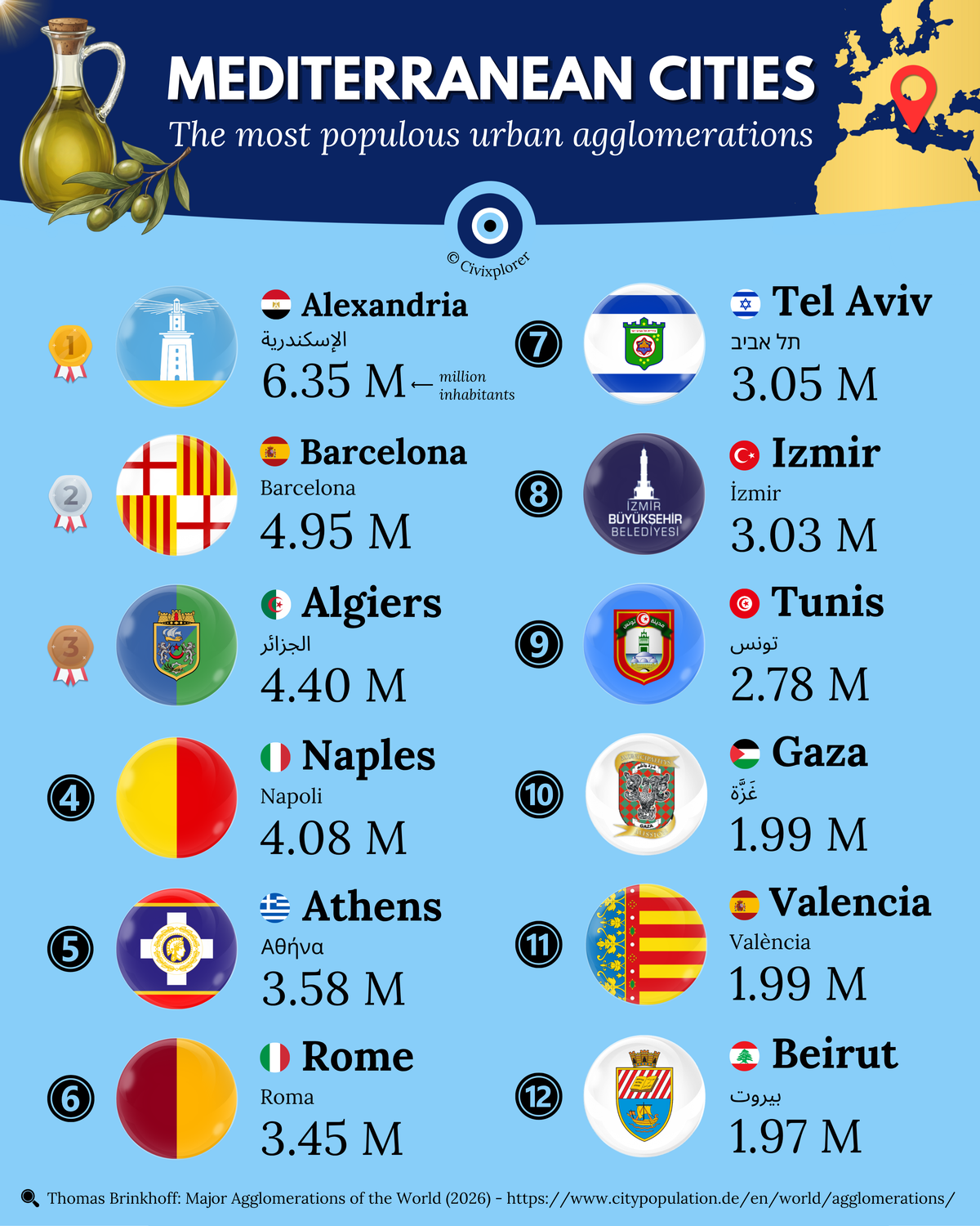
Largest Mediterranean Urban Agglomerations
Mediterranean urban megacities are shifting. Discover the 12 most populous urban agglomerations and the surprising forces driving their growth. Explore the data!

The eye of the world
Found 36 results for "Borders"
Mediterranean urban megacities are shifting. Discover the 12 most populous urban agglomerations and the surprising forces driving their growth. Explore the data!
Flags with dogs reveal centuries of loyalty, history, and local pride. Discover the fascinating origins of these canine symbols in global vexillology.
Lebanon is a unique mosaic of 18 religious sects. Discover how geography and history shaped this diverse map and its political reality. Learn more now!
Union Jack geometry dissected: discover which UK country occupies the most area and the historical reason Wales is missing. See the full breakdown here.
Switzerland’s linguistic borders are a masterclass in diversity. Discover how four national languages coexist within one of the world's most stable nations.
World population density is revealed in this map dividing 8 billion people into four equal parts. Can you guess which region holds the most surprises?
European area rankings reveal surprising shifts when strict continental borders are applied. Discover how transcontinental nations are redefined.
Mongol Empire peak expansion: Discover how the largest contiguous land empire in history looks on a modern map. See which 21st-century nations were once under its rule.
Canada's national flag history is a long journey of identity and design. Discover how the maple leaf replaced imperial symbols in this ultimate guide.
History's largest empires are ranked by territorial peak in this guide. Explore how these twelve global giants shaped our world and why they eventually fell.
European regional GDP data reveals a massive divide between centralized capitals and industrial hubs. Discover which regions drive the EU economy today.
Scramble for Africa 1913 map reveals how empires carved a continent on the eve of WWI. Discover the secrets behind the two nations that remained free.
Discover the hidden history of European flags through heraldry. Explore how coats of arms transform national symbols and what they reveal about the past.
Post-Soviet flags reimagined through the lens of Soviet design. Explore how modern sovereign symbols clash with historical templates in this visual analysis.
Red and yellow flags dominate the world’s visual history, from medieval legends to socialist revolutions. Explore the deep symbolism behind these colors now.
U.S. Middle East plans in 1919 envisioned a radical redrawing of the Ottoman Empire based on Wilson’s 14 Points. What if these borders actually existed?
States with limited recognition represent the messy reality of global diplomacy. Explore the 10 nations caught in political limbo—who recognizes them and why?
France's longest land border isn't in Europe. Discover how French Guiana creates a 730 km frontier with Brazil and why this map redefines global geography.
Cultural fault lines define nations that are neighbors yet worlds apart. Explore why geography doesn’t always dictate identity in our latest map guide.
Discover the world’s longest river systems and the science behind measuring them. From the Nile to the Amazon, explore how these massive waterways shape our planet.
Continental and maritime control reveals how nations project global power. Why do small nations like France dominate the oceans? Explore the data behind the maps.
Luxembourg is often mislabeled as a microstate. Discover the real data behind its size and why it stands out from other small countries.
Swiss flag history reveals why this iconic square design is so unique. Discover the meaning behind the white cross and see world flags reimagined in this style.
Cyprus history and its political division are visible in every border. Discover how a mixed republic became a partitioned island in just 14 years.
Persian dynasties represent over 2,500 years of cultural resilience. Explore the empires, from Cyrus the Great to the Safavids, that shaped the modern world.
Anti-Ottoman heraldry represents a bloody era of European history. Explore the origins of "Turk head" symbols and the brave families who earned them.
US language map explores historical migration and colonial roots. Discover why French, German, and especially Spanish define regional identities in this visual guide.
Flag meanings for blue, green, and yellow palettes reveal deep ties to nature and identity. Explore the fascinating history behind these global symbols.
Amazon rainforest geography is a complex puzzle spanning nine nations. Discover why Brazil dominates the basin and how France holds a stake in South America.
Africa’s urban landscape in 1913 revealed. Discover how the Scramble for Africa and indigenous roots shaped these historic metropolises. Explore the ranking now!
Indigenous populations in the Americas are thriving with millions of members. Discover how ancient legacies like the Quechua and Maya still shape the modern world.
USA geographic proximity revealed! Discover why many Americans actually live closer to a foreign seat of government than Washington D.C. in this map guide.
This map of the Thirteen Colonies reveals the geographic and cultural roots of the United States. Discover why these regions developed so differently before 1776.
Military aircraft fleet rankings for 2025 reveal a massive gap in global reach. Can anyone challenge the aerial dominance of the United States?
Critical minerals are the new oil of the 21st century. Discover which countries dominate the global supply chain and why some regions are falling behind.
European meat consumption patterns revealed! Discover why the continent is split into pork, poultry, and fish zones in this deep dive into culinary geography.
We rely on ads to keep this site free & running. Please disable your ad blocker and reload the page to continue.