
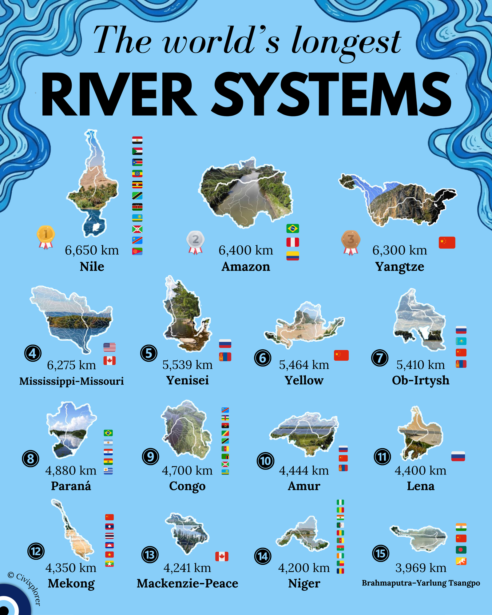
When we look at the world’s most formidable waterways, we are not just looking at single channels of water, but at vast, interconnected hydrological networks known as river systems. This distinction is crucial for understanding global rankings, as a system combines a main stem with its longest tributary from the farthest upstream source. For instance, the Mississippi-Missouri ranks as the fourth longest system in the world precisely because it combines the Missouri and Jefferson rivers with the Mississippi to trace a continuous flow to the Gulf of Mexico. Without this "system" metric, many of the world’s most famous rivers would drop significantly in the rankings.
The debate over the world’s "longest" river remains one of the most contentious topics in geography. While the Nile is traditionally recognized as the longest at 6,650 km, the Amazon follows closely at 6,400 km. However, some researchers argue that if the Amazon is traced to different sources in the Peruvian Andes, it could exceed 6,800 km, potentially dethroning the Nile. Regardless of the length debate, the Amazon is indisputably the largest by water volume and basin area, discharging more water than the next seven largest rivers combined.
Beyond the science of measurement, these river systems play a critical role in global geopolitics. Heavily shared basins like the Nile, which spans 11 countries, often face diplomatic tensions over water rights, such as the current disputes regarding the Grand Ethiopian Renaissance Dam. In contrast, "national giants" like the Yangtze and Yellow rivers are contained entirely within China, allowing for unilateral control over massive engineering projects like the Three Gorges Dam.
Some of the most powerful river systems are often the most overlooked, particularly the Arctic titans of Siberia: the Yenisei, Ob-Irtysh, and Lena. These rivers flow northward into the freezing Arctic Ocean, creating a unique hydrological quirk. In the spring, the southern sections melt first, sending massive surges of water toward a still-frozen northern mouth, which results in catastrophic "ice jams" and widespread flooding across the Siberian tundra.
Further south, systems like the Brahmaputra-Yarlung Tsangpo demonstrate the raw power of nature, carving out the world's deepest canyon in the Himalayas before surging through India and Bangladesh. These systems are not merely lines on a map; they are the living arteries of our planet, sustaining civilizations, driving economies, and defining the very borders of our world.
Comments (0)
Join the Conversation
Login to share your thoughts with the community.
Login to Comment