
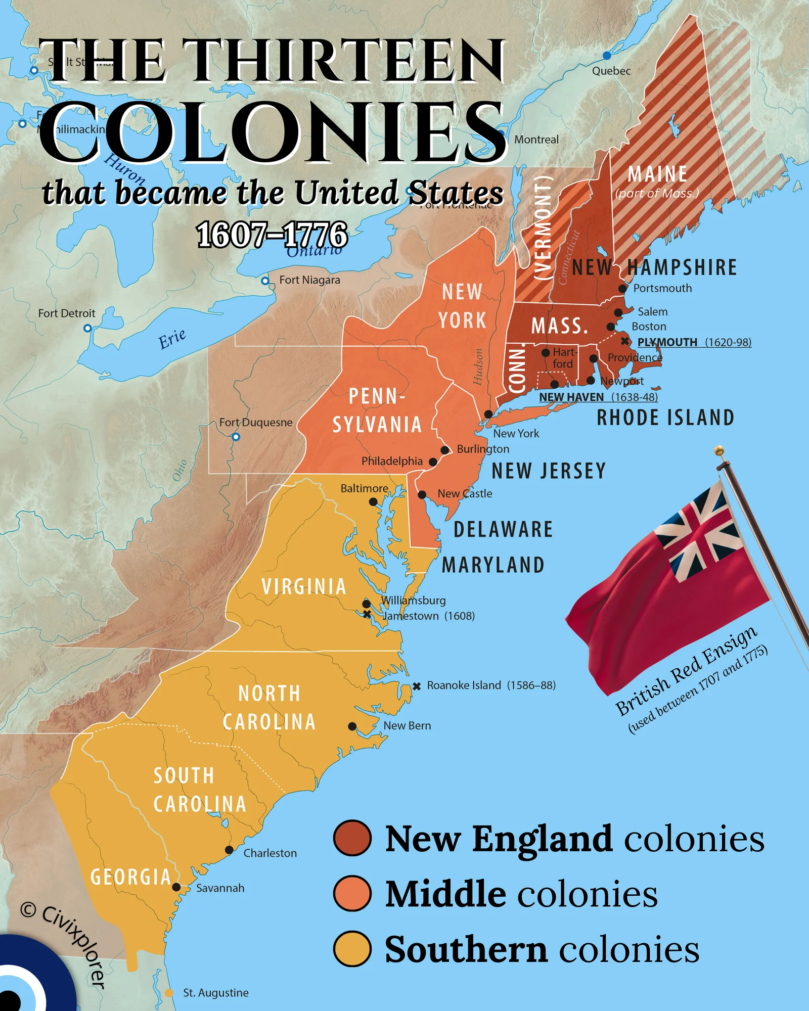
The historical landscape of the Thirteen British Colonies, spanning from 1607 to 1776, provides a fascinating look at how geography and culture shaped the foundations of the United States. This era was defined by three distinct regions—New England, the Middle Colonies, and the Southern Colonies—each driven by unique environmental factors and social goals.
Geography played the most significant role in these divisions. In the north, New England faced thin, rocky soil and harsh winters that made large-scale agriculture impossible. Instead, these colonies looked to the Atlantic, establishing themselves as global leaders in shipbuilding, fishing, and maritime trade. In contrast, the Middle Colonies became the "Breadbasket" of the continent. With fertile soil and a moderate climate, they produced massive quantities of grain and utilized deep-water ports in New York and Philadelphia to power their economies. Further south, the warm climate and rich soil facilitated a plantation economy focused on labor-intensive cash crops like tobacco, indigo, and rice.
Beyond economics, many colonies were founded as social or religious experiments. Pennsylvania, established by William Penn, served as a "holy experiment" for Quakers, fostering a level of religious tolerance that allowed Philadelphia to grow into a premier intellectual center. Maryland was envisioned as a haven for English Catholics, while Georgia was strategically founded in 1732 as a "buffer colony" to protect the valuable Carolinas from Spanish-held Florida.
The maps of this era also reveal interesting anomalies that differ from modern borders. For instance, Maine was historically part of Massachusetts, and Vermont was a disputed territory between New Hampshire and New York. One of the most significant features of the late colonial period was the Proclamation Line of 1763. Following the Appalachian Mountains, this line forbade colonists from settling further west to avoid conflict with Native Americans. This restriction essentially "bottled up" the population and became a primary catalyst for the American Revolution.
Finally, the visual identity of these colonies remained tied to the British Crown until the very end. The British Red Ensign, featuring the pre-1801 Union Jack, was the standard civil flag of the era. It serves as a reminder that despite their growing differences, these regions were legally and culturally bound to Great Britain until the Declaration of Independence in 1776.
Comments (0)
Join the Conversation
Login to share your thoughts with the community.
Login to Comment