
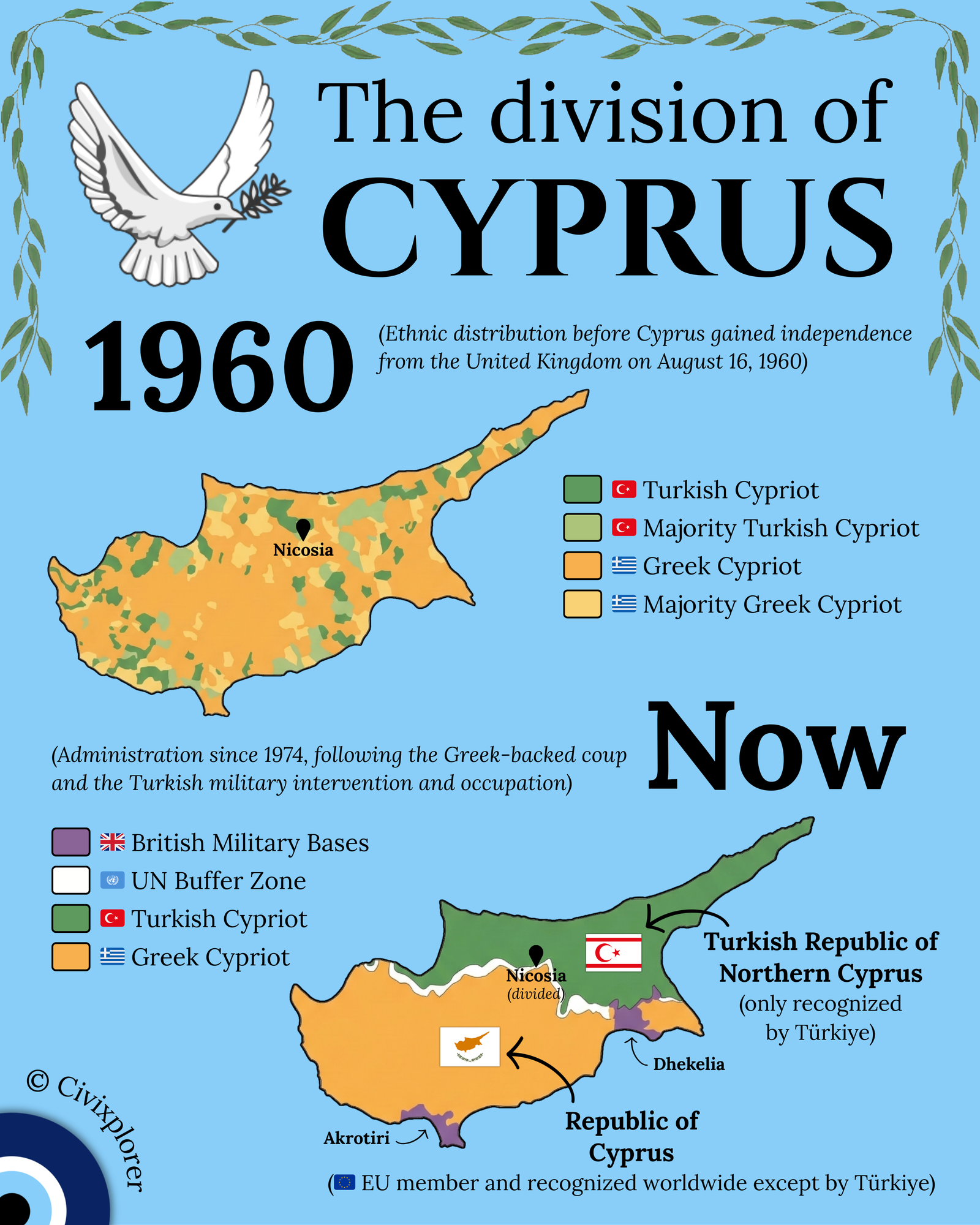
The modern map of Cyprus serves as a stark visual reminder of how quickly a nation’s demographic and political landscape can transform. To understand the current division, one must look back at the 1960 independence from British rule, when the island was a thoroughly intermixed patchwork of Greek and Turkish Cypriot communities. At that time, Greek-majority and Turkish-majority villages were scattered across the island, rather than being neatly separated by the north and south borders we see today.
The roots of the conflict lie in the competing nationalisms of the mid-20th century. The Greek Cypriot majority campaigned for Enosis (union with Greece), while the Turkish Cypriot minority favored Taksim (partition). Although the 1960 Zurich and London Agreements established a bi-communal republic with power-sharing safeguards, the arrangement proved fragile. By 1963, constitutional disagreements led to intercommunal violence, forcing many Turkish Cypriots into isolated enclaves and necessitating the deployment of UN peacekeepers.
The definitive breaking point occurred in the summer of 1974. A Greek-backed military coup aimed at overthrowing the president, Archbishop Makarios III, and annexing the island, triggered a massive military response from Türkiye, citing its rights as a guarantor power. This "Operation Attila" resulted in the occupation of approximately 36% of the island’s northern territory. The aftermath was a profound humanitarian crisis, leading to massive population exchanges where hundreds of thousands of people were displaced to either side of the newly formed Green Line.
Today, the island remains frozen in this outcome. The internationally recognized Republic of Cyprus (an EU member since 2004) controls the south, while the Turkish Republic of Northern Cyprus—recognized only by Türkiye—governs the north. Cutting through the heart of the capital, Nicosia, is the UN Buffer Zone, making it the last divided capital in the world.
Furthermore, the map highlights the enduring legacy of British colonialism through the Sovereign Base Areas of Akrotiri and Dhekelia. These two purple patches are not leased land but remain British soil, serving as strategic staging grounds for military operations in the Eastern Mediterranean. Situated at the crossroads of Europe, Asia, and Africa, these bases provide a permanent foothold near the Suez Canal and the Middle East, representing one of the final active remnants of the 1960 settlement.
Comments (0)
Join the Conversation
Login to share your thoughts with the community.
Login to Comment