
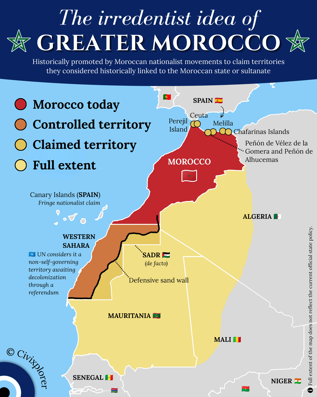
The concept of Greater Morocco is a nationalist and irredentist ideology that emerged prominently in the mid-20th century. Spearheaded primarily by Allal al-Fassi, a leader of the Moroccan nationalist Istiqlal Party, the ideology argued that the legitimate borders of the Kingdom should encompass all territories that historically pledged religious and political allegiance—the Bay'ah—to the Moroccan Sultan before the establishment of the French and Spanish protectorates in 1912.
At its peak, this maximalist vision sought to restore what nationalists viewed as the historical integrity of the Sharifian Empire, tracing its roots back to the Almoravid and Almohad dynasties. These historical justifications rested on pre-colonial patterns of influence, where authority was often defined by tribal allegiances and religious recognition rather than the fixed, exclusive borders common in modern nation-states.
Western Sahara remains the most significant and active geopolitical dispute depicted in this historical vision. Following Spain’s withdrawal from the region in 1975, a complex reality emerged on the ground. Today, the territory is physically divided by a 2,700-kilometer-long defensive sand wall, often called the Berm. Morocco exercises de facto administration over approximately 80% of the territory west of this wall. The remaining eastern portion is controlled by the Polisario Front, which declared the Sahrawi Arab Democratic Republic (SADR). The United Nations continues to classify Western Sahara as a non-self-governing territory, awaiting a final political settlement.
The map also highlights the ongoing dispute over the Spanish enclaves and islands along the northern coast. These include the autonomous cities of Ceuta and Melilla, as well as various islands such as the Chafarinas Islands and Peñón de Vélez de la Gomera. While Morocco views these territories as vestiges of European colonialism that disrupt its territorial integrity, Spain maintains that these "places of sovereignty" have been Spanish for centuries and are non-negotiable parts of the Spanish state. Interestingly, the Canary Islands sometimes appear in fringe nationalist claims due to geographic proximity, though this has never been official state policy.
Historically, the "Full Extent" of Greater Morocco was even more expansive, reaching into Mauritania, Northern Mali, and Western Algeria. These claims led to significant regional friction, most notably the Sand War of 1963, a border conflict between Morocco and Algeria over the regions of Tindouf and Bechar. Morocco also initially refused to recognize Mauritania’s independence in 1960, viewing the entire country as historically Moroccan. It took nearly a decade of diplomatic pressure before Morocco formally recognized Mauritania in 1969.
Today, it is essential to note that these maximalist historical claims do not reflect current official state policy. The modern Moroccan government has pragmatically focused its geopolitical efforts on Western Sahara and the northern enclaves, moving away from the broader Saharan claims of the 1950s and 60s. Understanding the map of Greater Morocco is crucial for anyone studying the history of decolonization and the complex layers of identity and sovereignty that continue to shape North African geopolitics.

Comments (0)
Join the Conversation
Login to share your thoughts with the community.
Login to Comment