
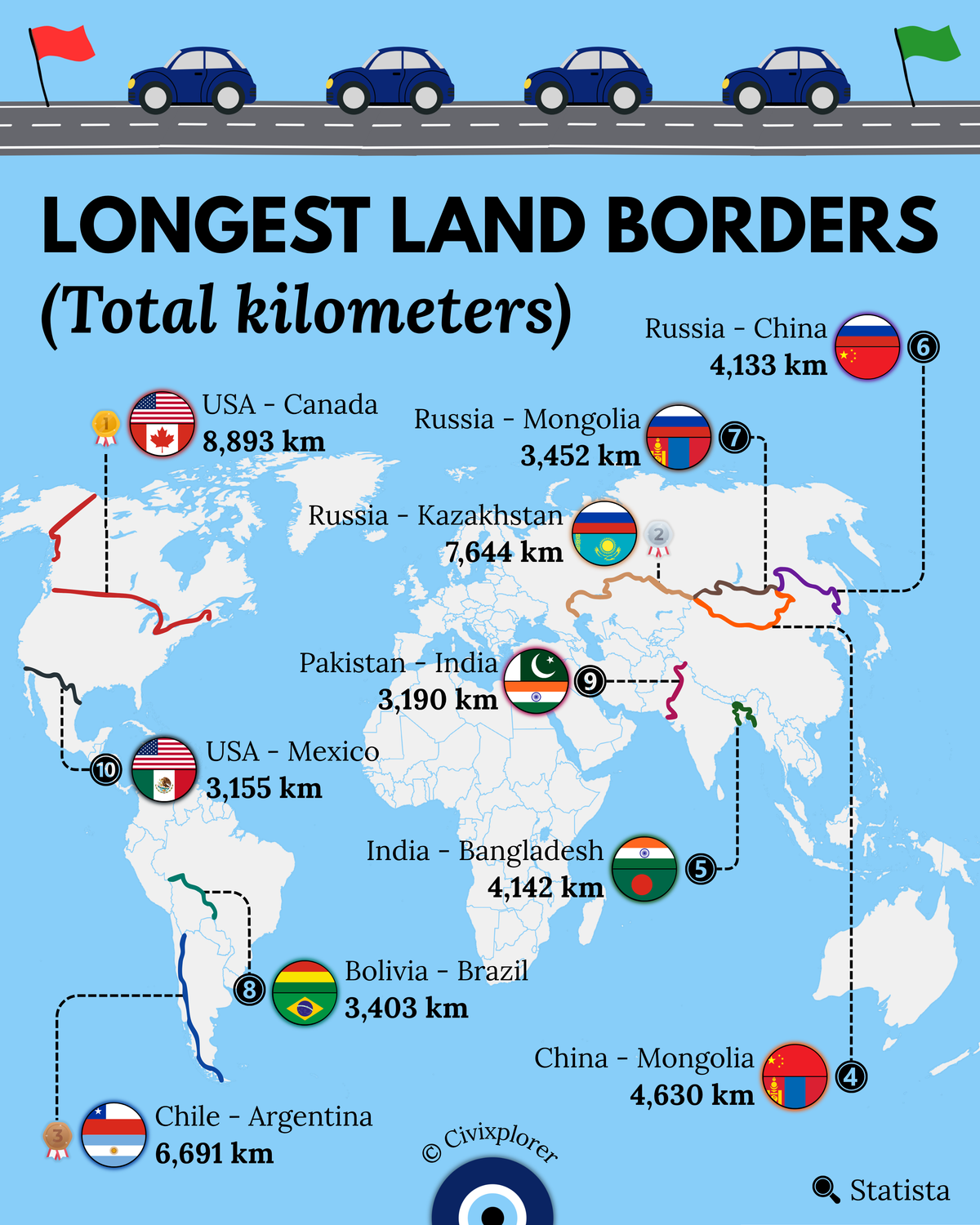
Borders are far more than mere lines on a map; they are the enduring legacies of imperial expansion, post-Soviet administrative shifts, and formidable natural topography. While we often think of them as political barriers, the world’s longest frontiers frequently exist between large countries whose historical growth and settlement patterns created enormous contact zones.
The Northern Giant: USA and Canada
Ranking as the longest international land border on Earth, the USA–Canada boundary stretches approximately 8,893 kilometers. Interestingly, this border is not continuous; it is divided into two distinct segments: the contiguous southern border and the boundary separating Alaska from Canada. Much of the western section famously follows the 49th parallel north, a geometric line established by the Oregon Treaty of 1846. To maintain visibility across thousands of kilometers of wilderness, a 6-meter-wide treeless zone known as "The Slash" is continuously cleared, making the border visible even from satellite imagery.
The Longest Continuous Line: Russia and Kazakhstan
While the North American border is split, the Russia–Kazakhstan boundary holds the title for the world's longest continuous land border, measuring 7,644 kilometers. This frontier is a relatively recent international development, having served as an internal administrative boundary within the USSR until its dissolution in 1991. The border primarily traverses the Eurasian steppe, and its creation was so sudden that it originally severed integrated Soviet infrastructure, such as railway lines that routinely dipped in and out of the newly sovereign territories.
The Spine of the Andes: Argentina and Chile
The third-longest border in the world belongs to Argentina and Chile, stretching 6,691 kilometers along the rugged crest of the Andes Mountains. This boundary is defined by extreme climate diversity, intersecting the hyper-arid Atacama Desert in the north and terminating in the freezing glaciers of the Southern Patagonia Ice Field. Historically, the border was negotiated to follow the highest peaks and the continental watershed, a principle that helped settle various territorial disputes over the last century.
Complexity and Enclaves: India and Bangladesh
Though Bangladesh is geographically small, its border with India is remarkably long at 4,142 kilometers due to its jagged, tortuous perimeter. This "Radcliffe Line" was drawn during the 1947 Partition of British India and, for decades, featured a complex system of territorial enclaves. At one point, it even contained the world's only third-order enclave—a piece of India inside a piece of Bangladesh, inside a piece of India, surrounded by Bangladesh. Most of these administrative labyrinths were finally resolved through a historic land swap agreement in 2015.
The Mongolian Wedge
In East Asia, the unique position of Mongolia creates two of the world's longest borders: its 4,630-kilometer frontier with China and its 3,452-kilometer boundary with Russia. Mongolia acts as a massive geographical wedge between these two giants. The Sino-Mongolian border is China's longest land frontier, largely following the harsh terrain of the Gobi Desert and ancient territorial demarcations.
Why These Borders Matter
These immense boundaries remind us that geography and history are inseparable. Whether they follow geometric parallels, mountain watersheds, or former imperial lines, these borders shape the economic integration, political stability, and cultural identity of the nations they define.
Comments (0)
Join the Conversation
Login to share your thoughts with the community.
Login to Comment