
It is a fantastic geopolitical mind-bender to realize that France’s longest land border is not shared with a European neighbor like Belgium or Spain, but with the South American giant, Brazil. This striking reality highlights France’s unique status as a truly transcontinental nation, with territories that extend its sovereignty far beyond the borders of the European "Hexagon."
The South American Surprise: Brazil and Suriname
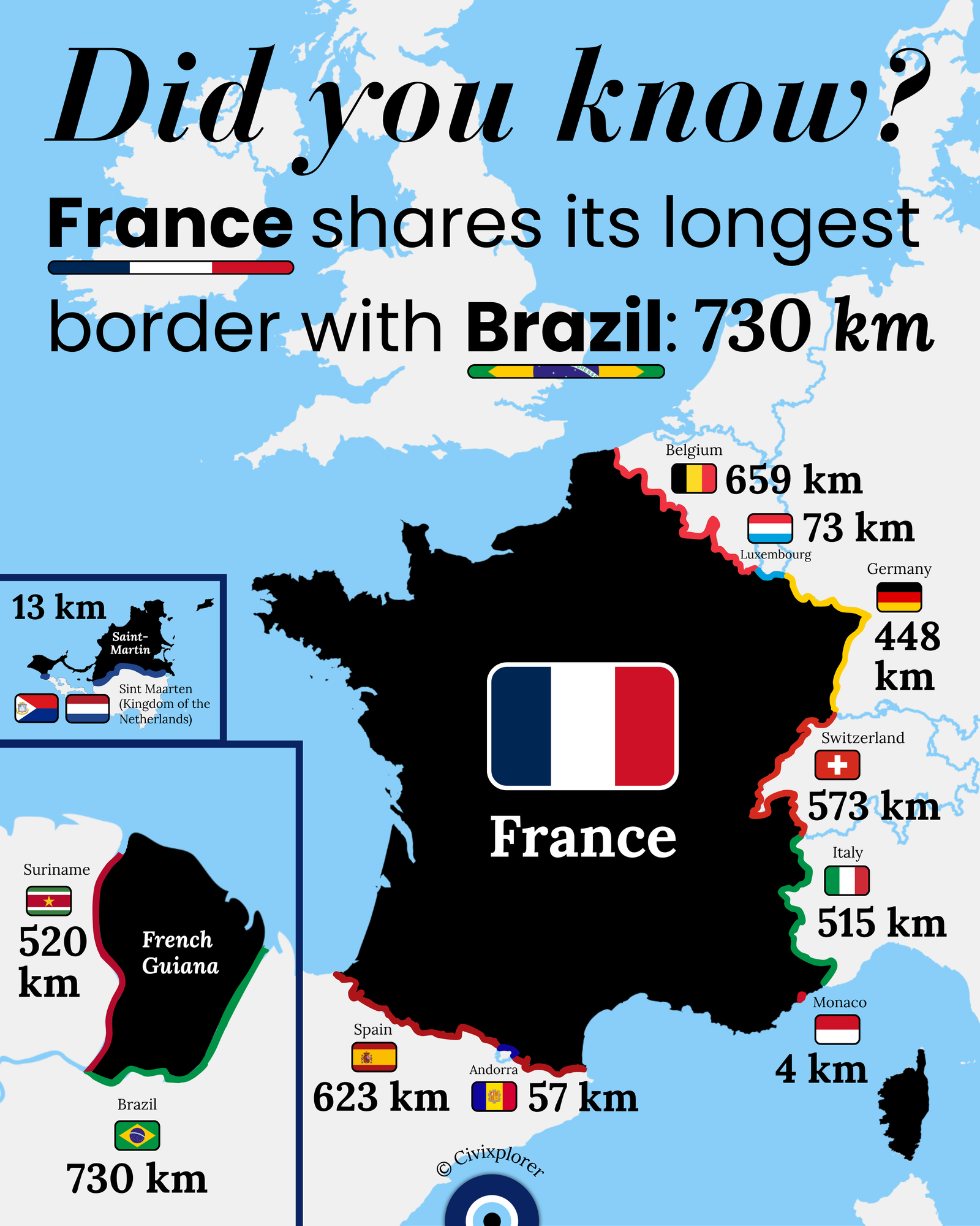
The fact that France shares a 730-kilometer border with Brazil—deeply embedded in the Amazon rainforest along the Oyapock River—is due to the territory of French Guiana. A common misconception is that French Guiana is a colony or a mere territory; in reality, it is a fully integrated Overseas Department and Region (DOM-ROM) of the French Republic. Its legal and political status is identical to that of mainland departments like Normandy or Provence.
Because French Guiana is legally France, it is also a part of the European Union. It is classified as an "Outermost Region," meaning the official currency is the Euro, and its citizens vote for the French President and send representatives to the National Assembly in Paris. This integration also gives France a 520 km border with Suriname, making France the only European country with a direct land presence on the South American mainland.
Strategic Sovereignty: The Guiana Space Centre
One might wonder why France maintained such a tight grip on this territory during waves of decolonization. A massive part of the answer lies in astrophysics and geopolitics. In 1964, France chose Kourou, French Guiana, as the site for its primary spaceport. Because the region is located just above the equator, the Earth’s rotation provides a natural centrifugal "slingshot" effect, saving immense amounts of fuel and allowing rockets to carry heavier payloads into orbit. Today, this facility ensures that Europe maintains independent access to space.
European Borders and Historical Anomalies
While the South American frontiers steal the spotlight, France’s European borders are full of historical quirks. Belgium holds the title for the longest European border at 659 km, followed closely by Spain at 623 km. The Spanish border is particularly famous for its anomalies, such as Pheasant Island, a "condominium" where sovereignty flips between France and Spain every six months.
A bizarre constitutional reality exists in Andorra, where the President of France serves as a Co-Prince alongside the Spanish Bishop of Urgell. This makes the French President the only democratically elected leader who is simultaneously a monarch of another sovereign country.
The Caribbean Connection
Finally, the map reveals a tiny but fascinating 13 km border with the Netherlands. This border is located on the Caribbean island of Saint Martin, which has been divided between the two nations since the 1648 Treaty of Concordia. It represents a direct, physical land border between the French Republic and the Kingdom of the Netherlands that simply does not exist on the European continent.
Ultimately, these borders are the living scars and remnants of centuries of exploration, treaties, and modern strategy. France’s geography proves that a modern nation-state can be a global patchwork, bridging continents and oceans under a single flag.
| Position | Country | Border Length (km) |
|---|---|---|
| 1 | Brazil | 730 |
| 2 | Belgium | 659 |
| 3 | Spain | 623 |
| 4 | Switzerland | 573 |
| 5 | Suriname | 520 |
| 6 | Italy | 515 |
| 7 | Germany | 448 |
| 8 | Luxembourg | 73 |
| 9 | Andorra | 57 |
| 10 | Netherlands | 13 |
| 11 | Monaco | 4 |
Comments (0)
Join the Conversation
Login to share your thoughts with the community.
Login to Comment