
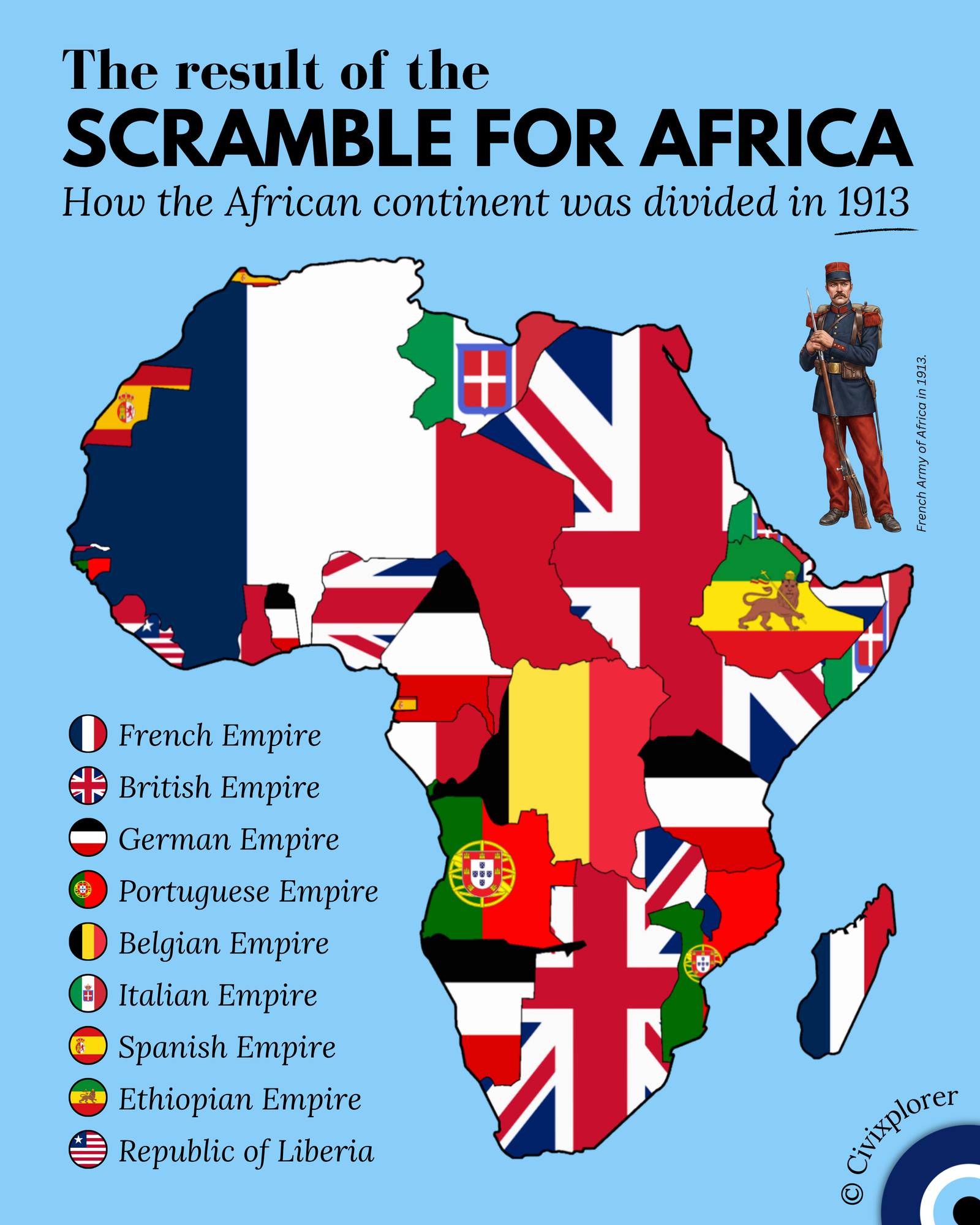
The year 1913 represents the absolute high-water mark of European imperial partition in Africa. Captured just one year before the outbreak of World War I, this snapshot illustrates a continent almost entirely transformed into a patchwork of foreign national symbols. While Europeans controlled only about 10% of Africa in the 1870s, by the time this map was finalized, over 90% of the landmass had been incorporated into various European empires.
The Mechanics of the Scramble
The rapid invasion and colonization shown here were largely formalized during the Berlin Conference of 1884–1885. It was here that European powers established the principle of effective occupation, meaning a nation had to demonstrate actual administrative control to claim a territory. This diplomatic agreement prevented immediate war between the colonizing powers but accelerated a frantic land grab that ignored ethnic, linguistic, and historical African realities.
The Lone Survivors: Ethiopia and Liberia
In a sea of imperial flags, two territories stand out for their independence. The Ethiopian Empire remains the most significant success story of indigenous resistance. Under Emperor Menelik II, Ethiopian forces decisively defeated an invading Italian army at the Battle of Adwa in 1896, forcing European powers to recognize Ethiopia as a sovereign state.
Liberia, on the west coast, maintained a different kind of independence. Founded in 1822 by the American Colonization Society as a settlement for freed Black Americans, it was viewed as falling within the United States' sphere of influence. This unofficial protectorate status largely shielded it from European conquest.
Visions of Empire: Britain and France
The map highlights the contrasting strategies of the two largest players. The British territories, draped in the Union Jack, reflect the grand "Cape to Cairo" ambition championed by Cecil Rhodes, aiming for a continuous red corridor from Egypt to South Africa. However, in 1913, this dream was interrupted by German East Africa.
France claimed the largest continuous landmass, spanning West and Equatorial Africa. Because France faced a stagnant birth rate at home, they heavily integrated these territories into their military strategy. The French Army of Africa, including the Senegalese Tirailleurs, became essential for garrison duty and would soon be deployed to the trenches of the Western Front.
Late Players and Tragic Legacies
The German presence in Togoland, Kamerun, South West Africa, and East Africa represents a late but aggressive entry into the colonial race under Kaiser Wilhelm II’s Weltpolitik. These holdings were often highly militarized and were the sites of early 20th-century atrocities, such as the Herero and Namaqua genocide.
In the center of the map lies the Belgian Congo. By 1913, this territory was transitioning from the private, brutal fiefdom of King Leopold II to a formal state colony. The legacy of Leopold’s Congo Free State, characterized by forced-labor atrocities in the rubber trade, remains one of the darkest chapters of this era.
This 1913 map freezes a moment of apparent imperial stability that would vanish within months. The Treaty of Versailles would soon erase the German flag from the continent, but the arbitrary borders drawn in European capitals would remain, shaping the geopolitical and social challenges of modern Africa for a century to come.
Comments (0)
Join the Conversation
Login to share your thoughts with the community.
Login to Comment