
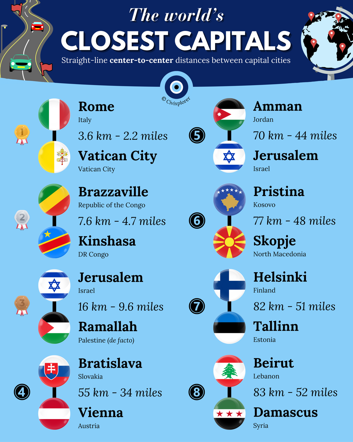
The distribution of national capitals across the globe often follows a predictable pattern of distance and isolation, yet certain regions present a fascinating geographical anomaly. When measuring straight-line, center-to-center distances, several capital pairs sit within a few dozen kilometers of one another. These proximities are rarely the result of random urban sprawl; instead, they reveal profound stories of historical imperial fracturing, natural transit corridors, and contested post-colonial borders.
The Enclave Illusion: Rome and Vatican City
At just 3.6 kilometers apart, Rome and Vatican City represent the world’s closest capital pair. This unique arrangement is a methodological artifact of Vatican City being an independent microstate entirely enclaved within the Italian capital. The physical distance between their borders is effectively zero. This sovereignty was established through the 1929 Lateran Treaty, which resolved the "Roman Question" after the unification of Italy. Today, the border is so seamless that visitors can cross from Rome into the heart of the Holy See on foot, often marked only by a white line in St. Peter’s Square.
The Riverine Rivals: Kinshasa and Brazzaville
Excluding enclaves, Kinshasa (DRC) and Brazzaville (Republic of the Congo) hold the title for the world’s closest capitals of two distinct sovereign nations. Separated by only 7.6 kilometers, they sit directly opposite each other on the banks of the Congo River. Despite their extreme proximity and a combined population exceeding 17 million people, there is currently no permanent road bridge connecting them. Their development as separate entities was a product of the 19th-century "Scramble for Africa," where French and Belgian colonial outposts were established on opposite banks of the river to secure trade routes above the Livingstone Falls.
Contested Sovereignty in the Levant
The proximity of Jerusalem and Ramallah (16 km) illustrates how political boundaries can make nearby places feel much further apart than their geography suggests. While Jerusalem is designated as a capital by Israel, Ramallah serves as the de facto administrative center of the Palestinian Authority. Similarly, the short 70-kilometer distance between Amman and Jerusalem reflects the compact geography of the Levant, where borders were redrawn multiple times throughout the 20th century following the collapse of the Ottoman Empire and subsequent regional conflicts.
The Danubian Imperial Legacy
In Europe, Vienna and Bratislava are the closest pair of sovereign national capitals, separated by only 55 kilometers. Both cities developed along the Danube River, a vital transportation artery. Their closeness is a legacy of the Habsburg Monarchy, where Bratislava (then Pressburg) served as a coronation city for Hungarian kings. While the Iron Curtain once turned this short distance into a heavily fortified ideological front line, today they form a highly integrated "Twin City" region within the European Union.
Natural Boundaries and Partitioning
Other notable pairs include Helsinki and Tallinn (82 km), which face each other across the Gulf of Finland. Their relationship has evolved from Soviet-era isolation to a modern maritime economic hub, with ambitious proposals for an undersea rail tunnel to further bridge the gap. In the Middle East, Beirut and Damascus (83 km) sit on opposite sides of the Levant mountains, their proximity a reminder of the 1920 French Mandate that partitioned once-interconnected Ottoman provinces into separate nation-states.
Ultimately, these close pairings demonstrate that capital cities are political creations. Their locations preserve centuries of history, illustrating how mountains, rivers, and treaties continue to shape the world's political map.
Comments (0)
Join the Conversation
Login to share your thoughts with the community.
Login to Comment