
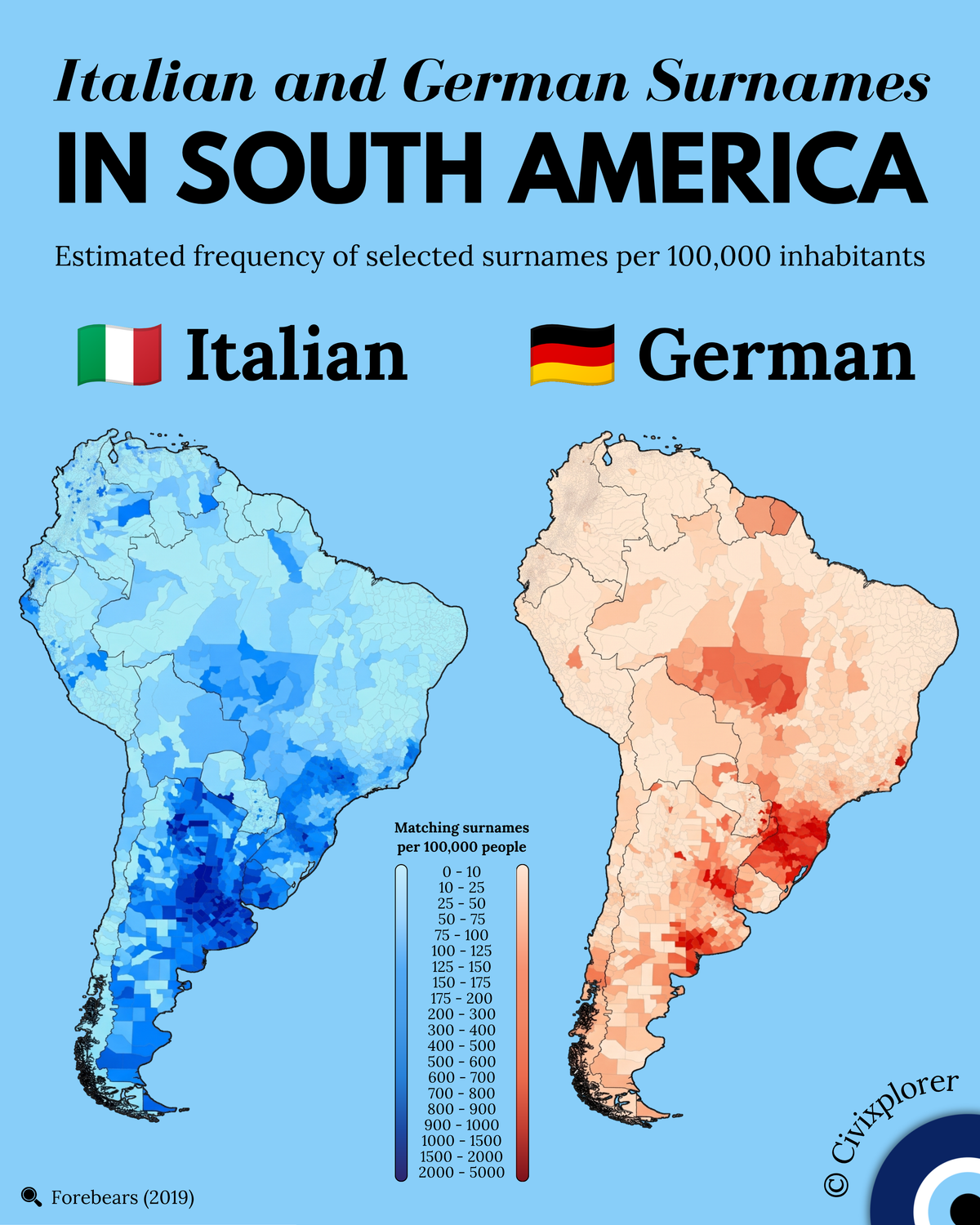
The geographical distribution of European family names across South America provides a fascinating window into historical immigration policies and demographic transformations. Based on 2019 data from Forebears, the dual map visualizes the estimated frequency of selected high-density Italian and German surnames per 100,000 inhabitants across subnational administrative divisions. Rather than measuring total genetic ancestry, the visualization tracks curated diagnostic surnames—such as Rossi or Bianchi for Italy, and Müller or Schneider for Germany—against a logarithmic-style non-linear scale that isolates intense demographic epicenters without flattening lower-density regions.
On the Italian map, the deepest navy-blue concentration blankets central-eastern Argentina and Uruguay, alongside key regions of southern Brazil. Driven by the mass transatlantic migration wave between 1870 and 1930, over four million Italians crossed the ocean, with 2.5 to 3 million settling in Argentina alone. Because Argentina had a relatively small baseline population at the time, this massive inflow resulted in an unprecedented surname density across the Argentine Pampas, Buenos Aires, Santa Fe, Córdoba, and Entre Ríos. In Brazil, while São Paulo state received the largest absolute headcount of Italian immigrants to work on coffee plantations after the abolition of slavery, the highest subnational per-capita surname densities appear in the rural agricultural colonies of the southern highlands, including Rio Grande do Sul, Santa Catarina, and Paraná.
In contrast, the German surname map demonstrates a sharply localized center of gravity centered primarily in southern Brazil. Imperial Brazil began establishing state-sponsored German-speaking smallholder colonies as early as 1824 in São Leopoldo, expanding mid-century into Blumenau and Joinville in Santa Catarina. Although total German immigration to South America was significantly smaller in absolute headcount compared to Italian inflows, these highland settlements maintained strong linguistic endogamy and geographical isolation for generations. This demographic preservation generated extreme per-capita red shading in Santa Catarina and Rio Grande do Sul that matches the density of the Argentine Pampas. Outside Brazil, distinct German surname enclaves visible on the map track Volga German agricultural villages in Argentina's Entre Ríos, state-directed settlement in Chile's Lake District, and historic Mennonite agricultural colonies in the Paraguayan Chaco and Bolivia.
One of the most compelling insights from the visual data is the presence of secondary surname hotspots deep within the continent's interior. The prominent orange-red belt stretching across Mato Grosso, Mato Grosso do Sul, and Rondônia does not represent direct 19th-century European landings, but rather a massive 20th-century internal migration wave. Beginning in the 1970s, descendants of German and Italian settlers from southern Brazil—known as sulistas—moved thousands of kilometers northward along newly constructed highway corridors to pioneer mechanized agriculture in the Cerrado. Other striking features include the isolated mountain enclaves of Espírito Santo, where Pomeranian and Venetian dialects persisted, post-war urban migrations to Venezuela and Lima, and onomastic Dutch-German overlap in Suriname. Ultimately, the map illustrates how historical state policies, land colonization, and subsequent internal migrations created a durable, multi-layered surname landscape across South America.

Comments (0)
Join the Conversation
Login to share your thoughts with the community.
Login to Comment