
The study of physical geography often reveals a hidden symmetry that geographers and topologists call geographical duality. This concept suggests that the Earth's surface operates like a puzzle made of positive and negative space, where landforms and water bodies mirror each other's structures. By understanding this relationship, we can see the world not as a collection of isolated features, but as a balanced system of reciprocal shapes.
The Montessori Connection to Visual Geography
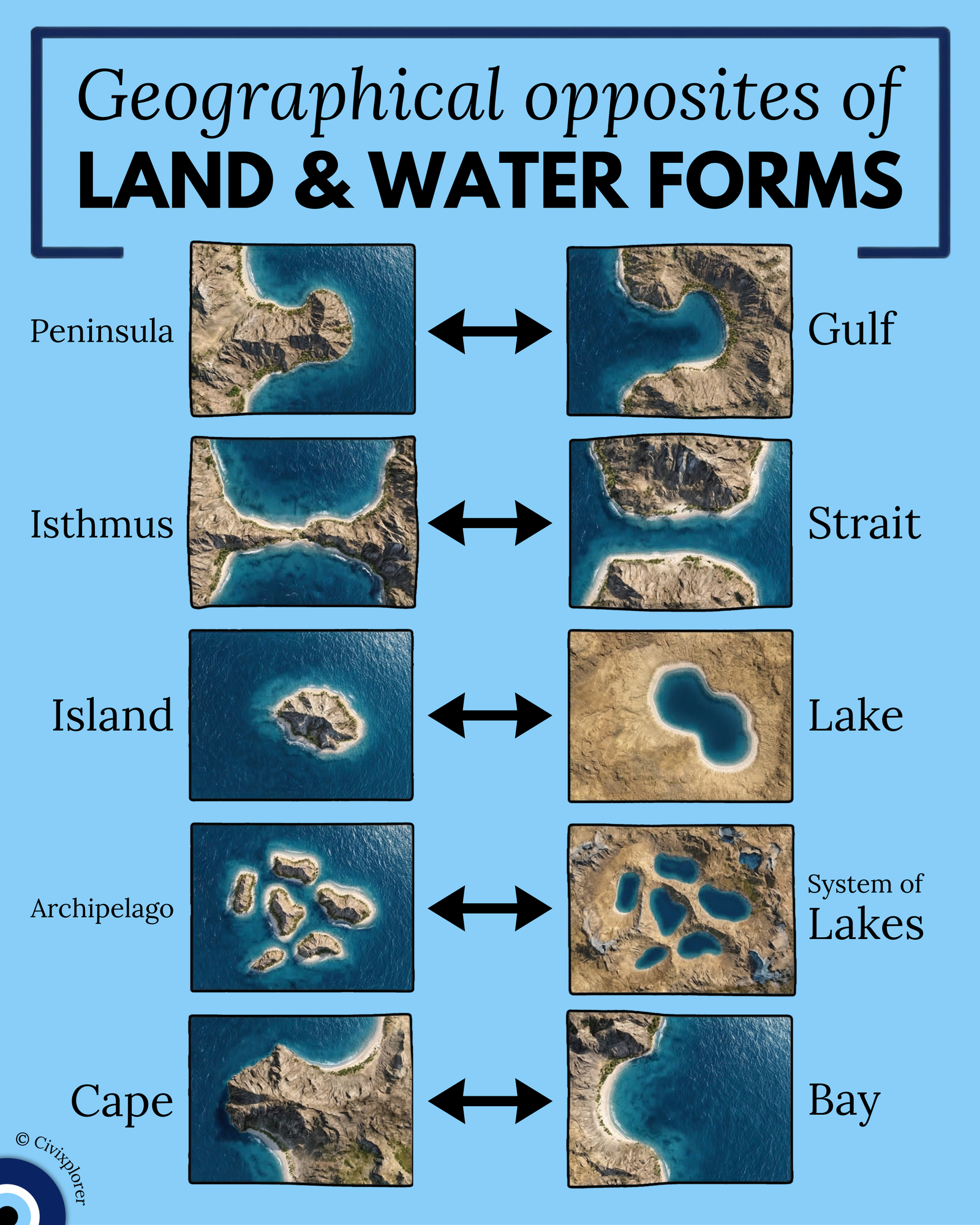
This visual approach to learning is deeply rooted in Montessori geography curricula. For over a century, the use of hands-on materials, such as sand-and-water trays, has helped students realize that if an island is "land completely surrounded by water," then a lake is "water completely surrounded by land." This inversion logic makes complex geographical concepts intuitive. When we look at satellite imagery, this duality becomes an "aha!" moment; the protruding landform on one side is the indented waterform on the other, simply with the colors reversed.
Geological Forces and the Sculpture of the Earth
These parallel formations are rarely coincidences. Instead, they are the result of the same tectonic and climatic forces acting upon the Earth’s crust. One of the most significant factors is sea level change. During historical periods like the last Ice Age, lower sea levels turned current straits (like the Bering Strait) into land bridges or isthmuses.
Furthermore, glacial carving acts as a master sculptor for both sides of the coin. In land-locked regions like Canada or Finland, retreating glaciers gouged out the earth to leave behind a system of lakes. Conversely, in coastal regions like Greece or Chile, the exact same glacial action carved deep valleys that, when flooded, created massive archipelagos.
The Strategic Importance of Geographical "Chokepoints"
The pairing of the isthmus and the strait represents perhaps the most impactful duality in human history. Both act as critical geographical funnels:
- The Strait: Connects two oceans but pinches naval trade into a tight corridor. Controlling a strait like the Strait of Hormuz often means controlling the global supply chain.
- The Isthmus: Connects two landmasses but acts as a massive barricade to maritime travel.
Throughout history, humans have spent decades and billions of dollars to "fix" this geography by carving artificial straits—known as canals—through isthmuses to facilitate global trade. Whether it is a peninsula mirroring a gulf or a cape defining a bay, these land and water forms are not in conflict; they are inverses that define the very boundary of our world.
Comments (0)
Join the Conversation
Login to share your thoughts with the community.
Login to Comment