
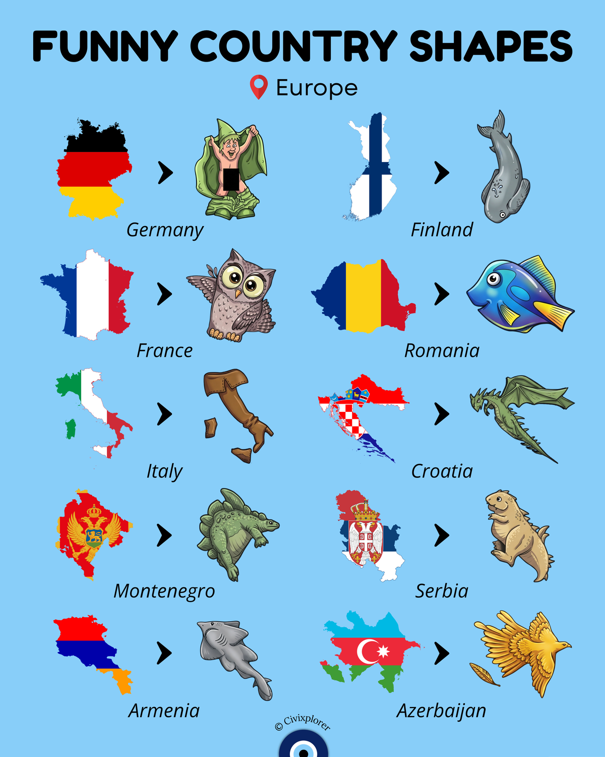
The human brain possesses an incredible knack for pattern recognition, a psychological phenomenon known as cartographic pareidolia, which leads people to see recognizable animals, characters, and objects within the abstract borders of nations. This creative concept gained widespread internet popularity through German creator Zackabier’s 2012 project visualising European boundaries as whimsical caricatures. While seeing dragons, whales, or boots on a map provides an entertaining visual memory aid, these national outlines were never intended as artwork. Instead, every twist and turn of a national border represents a dramatic story written by centuries of geological forces, wartime treaties, and shifting political empires.
Certain iconic shapes stem directly from natural physical geography rather than political negotiations. The most universally recognized example of map pareidolia is Italy, affectionately known as lo Stivale or the boot. Rather than being drawn by a monarch, the Italian boot was forged by tectonic collisions between the Eurasian and African plates, which pushed up the Apennine Mountains along the peninsula. In contrast, other silhouettes carry deep cultural and political history. Finland is often drawn in modern caricatures as a plunging fish or whale. However, Finns historically recognized their country’s silhouette as the Maiden of Finland (Suomi-neito), a national personification depicted since the nineteenth century as a woman with two raised arms. Following the 1944 Moscow Armistice, Finland was forced to cede the Petsamo territory to the Soviet Union, effectively amputating the maiden's right arm and permanently reshaping the national outline into the streamlined figure seen today.
In Southern and Western Europe, intricate borderlines reflect centuries of imperial rivalries and diplomatic agreements. Croatia displays a striking boomerang or flying dragon shape that wraps completely around Bosnia and Herzegovina. This unique silhouette was forged through centuries of conflict between the Ottoman, Habsburg, and Venetian empires, eventually formalized in diplomatic agreements like the 1699 Treaty of Karlowitz. Meanwhile, France is playfully illustrated in artistic sets as an owl, despite being officially and universally nicknamed L'Hexagone due to its balanced, six-sided perimeter bounded by three maritime and three terrestrial borders.
Along the continental frontier, nations like Armenia and Azerbaijan—reimagined in visual jokes as an angel shark and a golden bird—highlight the complex geography of the Caucasus mountain divide bridging Europe and Asia. Armenia's southern Syunik province creates a land corridor that physically separates mainland Azerbaijan from its Nakhchivan exclave. Other playful pairings across the continent, such as Germany depicted as a cloaked flasher, Romania as a blue tang fish, Montenegro as a stegosaurus, and Serbia as a standing rodent, demonstrate how cloud-gazing logic can turn complex cartography into an accessible, captivating visual lesson. By pairing imaginative caricatures with real historical context, maps transform from static lines into living records of human history.

Comments (0)
Join the Conversation
Login to share your thoughts with the community.
Login to Comment