
When we look at a standard world map, Alaska often appears as a remote, frozen corner of the Northwest, isolated from the rest of the world. However, this is largely an illusion created by the Mercator projection, which distorts distances and sizes near the poles. In reality, Alaska sits at a global crossroads, acting as a strategic bridge between North America, Asia, and Europe.
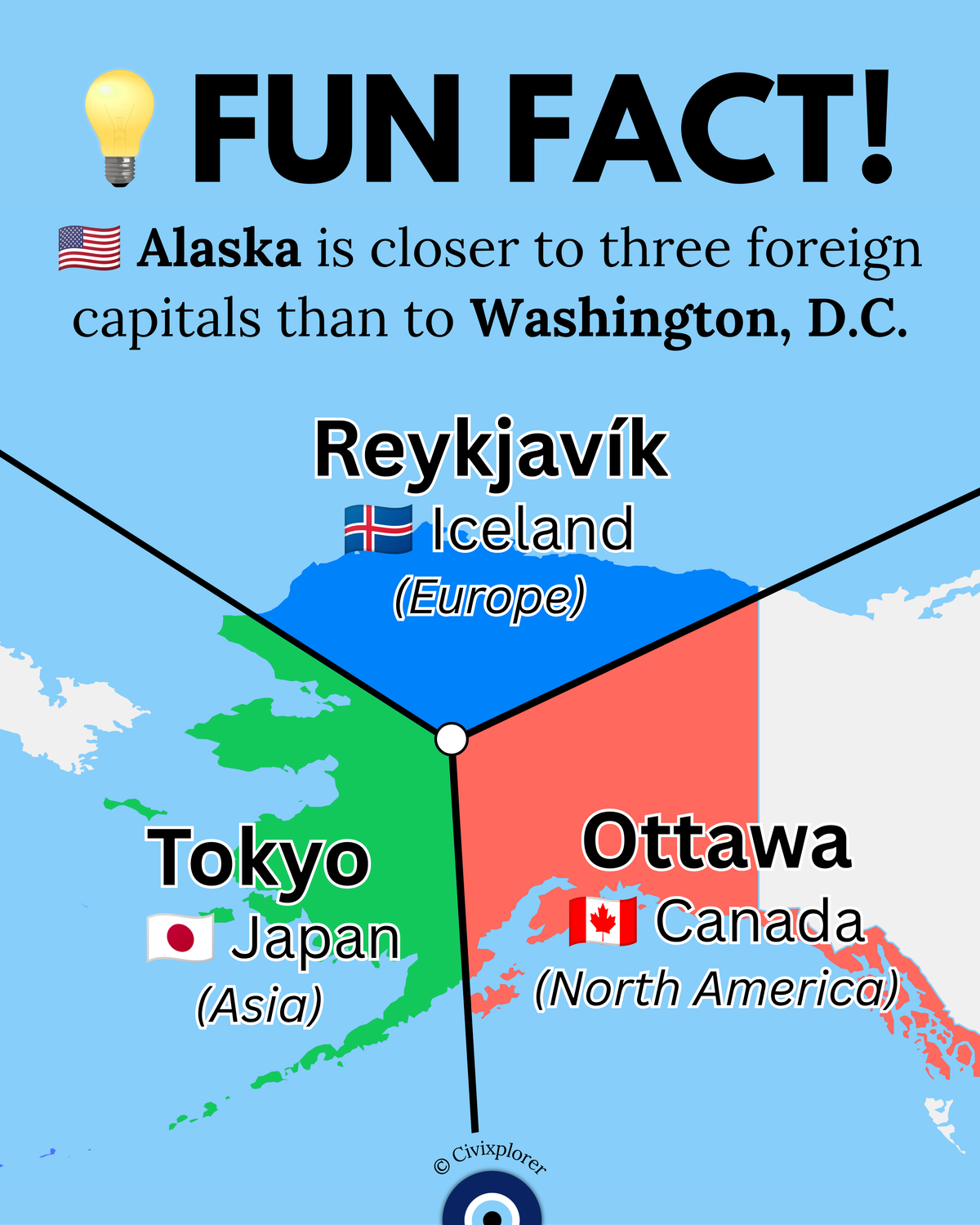
A fascinating way to visualize this is through a Voronoi diagram, a mathematical method that divides a territory based on the shortest distance to specific points. When applied to Alaska, we discover a counterintuitive truth: large portions of the state are geographically closer to the capitals of Japan, Iceland, and Canada than they are to their own national capital, Washington, D.C.
The Green Zone: Tokyo and the Asian Connection
Western Alaska and the Aleutian Islands represent the state's proximity to the East. The Aleutian chain stretches so far west that it actually crosses the 180th meridian into the Eastern Hemisphere. For residents of places like Attu Island, Tokyo is only about 2,000 miles away, while Washington, D.C. sits over 4,500 miles across the continent. This proximity made Alaska a vital theater during World War II and continues to make it a critical area for North Pacific trade and defense.
The Blue Zone: Reykjavík and the Arctic Shortcut
The most surprising proximity is found in Northern Alaska. Because the Earth is a sphere, the shortest route between two points—known as a Great Circle path—often passes over the poles. From the North Slope, the distance to Reykjavík, Iceland, is roughly 2,500 to 2,800 miles. By comparison, a flight to Washington, D.C. from the same northern region is significantly longer, exceeding 3,400 miles. This "polar shortcut" is why the Arctic is increasingly seen as a strategic corridor for international aviation and maritime commerce.
The Red Zone: The Shadow of Ottawa
In Eastern Alaska and the Panhandle, geography follows a more predictable but no less interesting pattern. Because Ottawa is situated further north than Washington, D.C., any path from Alaska to the U.S. East Coast essentially "passes through" Canada’s sphere of proximity first. For much of the Alaskan interior, the Canadian capital is hundreds of miles closer than the American one.
Beyond the Map: A Strategic Reality
This geographic layout is not just a trivia fact; it has real-world consequences. It explains why Anchorage became one of the busiest international cargo hubs in the world, serving as a "technical stop" for aircraft traveling between major global markets. It also highlights why Alaska was historically mocked as "Seward’s Folly" but eventually recognized as the "eye of the world" for its unparalleled access to three different continents. Understanding Alaska requires us to put down the flat map and look at the globe, where the state reveals itself not as an edge, but as a central hub of the Northern Hemisphere.

Comments (0)
Join the Conversation
Login to share your thoughts with the community.
Login to Comment